Almost everybody knows that Millwall is named after the windmills that once occupied the river bank (or ‘wall’) down the west side of the Isle of Dogs. The earliest of these mills was built in 1679 on land owned by George Byng just west of the present day Manilla Street. On most maps it was referred to as ‘Brown’s Mill’, and it was one of seven mills featured on Gascoyne’s 1703 map of London.
Extract of Gascoyne’s map

Detail of a drawing in a 1754 issue of Gentleman’s Magazine
Eventually there were twelve recorded mills on the Island. They had a variety of functions, but mostly they were oil mills – grinding mills designed to crush oil-bearing seeds, such as rapeseed or linseed, which would then be pressed to extract vegetable oils. These oils could be used as lubricants, fuel for lamps and in the preparation of food. The pomace or press cake – the remaining solid material from which the oil had been extracted – was also used as animal feed.
Oil milling formed the basis for the development of a wider oil industry on the Island. One of the earliest examples of this industry was that of Sir Charles Price, who set up his oil works in 1805 on land formerly occupied by Brown’s Mill (see A Wander Around the Block Near the City Arms):
…erecting a complex of buildings for crushing rapeseed and linseed, and the production and storage of tar, oils, turpentine and varnish. An old windmill on the site, long used for seed-crushing, was converted to an oil-refining house.
– Survey of London
Windmills in Britain remained popular until the mid-19th century, before their decline following the arrival of steam-driven roller mills. In Millwall, however, the decline started earlier; most became defunct and were demolished in the few decades following 1800.
Drawing of two windmills at Millwall.
The primary reason for their decline was the arrival of the West India Docks, which opened in 1802. This was an impetus for industry to spread southwards down the Millwall riverside, accompanied by the development of housing ‘inland’. The Island very quickly lost its pastoral character, as more money was to be made in the manufacture of all things to do with iron and ships (or both). By this time, anyway, London was growing rapidly and was swallowing up what was once Stepney, Poplar and Essex farmland.
The southernmost of the seven mills, known as Theobald’s Mill survived the longest. Survey of London:
Theobald’s Mill was built c1701 on a 99-year lease granted by John Lockey of Barking to Daniel Mayhew of Rotherhithe, miller. The site had a long river front of 290ft. William Peace, another Rotherhithe miller, acquired the lease in 1763 and in the following year Peace assigned it to an oil-presser, William Smith of Poplar. In 1788 George Byng granted a new 90-year lease of the site, including the mill, apparently rebuilt as a smock mill, to a Wapping biscuit baker, Murty Cullen, at a rent of two guineas.
It appears as Ward’s Mill on Gascoyne’s 1703 map, and a century later was known as Theobald’s Mill. By this time part of the ground was a shipyard, and in the mid-1830s the site became Weston’s cement and plaster works.

1819

1819 map, zoomed-in
Not being an expert on windmills, I had to Google ‘smock mill’. According to Wikipedia, it is a type of windmill that “consists of a sloping, horizontally weatherboarded or thatched tower, usually with six or eight sides, and made of wood. It is topped with a roof or cap that rotates to bring the sails into the wind. This type of windmill got its name from its resemblance to smocks worn by farmers in an earlier period”.
Only two of Millwall’s mills were smock mills, so this helps us to identify Theobald’s Mill in old drawings and paintings. The Wikipedia description certainly matches the appearance of the mill in the following drawings, both made in the 1830s.

Millwall,. W. Tombleson, 1830.

1837
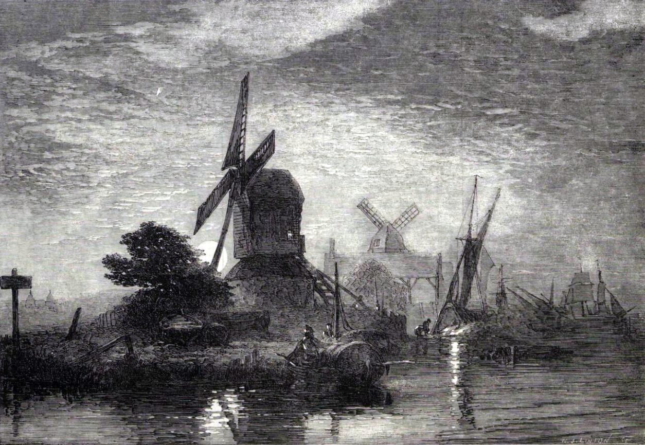
The 1837 drawing also features large quantities of timber in the foreground, possibly belonging to the shipyard mentioned in Survey of London. The following painting, made in 1843, is clearly of the same mill (I am curious if the drawing is in fact a sketch made by the same artist, in preparation for the painting). By this time, at least one of the out-buildings of Theobald’s Mill was reported as being used as a public house, most frequently referred to as “The Windmill”.

1843
The letters on the sign are difficult to read, but they appear to spell “Truman Barclay”, the names of two breweries (Barclay’s brewery was just across the river in Southwark).

By this time, Theobald’s Mill was the only mill still standing in Millwall, as demonstrated by this 1840 map:

1840
Just a few years later, though, it was no longer functional, and its sails had been removed. In his 1853 book, A Descriptive Historical and Statistical Account of Millwall, commonly called the Isle of Dogs, Benjamin Harris Cowper describes the remains of the windmills:
‘There is a view of London and Westminster, (published in 1752) taken from One Tree Hill, in Greenwich Park. This view includes the Isle of Dogs, and represents seven windmills upon the the river bank, opposite Deptford, and the same number of smaller buildings, one beside each of the mills. Chapel House is also shown.
Another dated 1754, (in the Gentleman’s Magazine,) is in all respects similar. Some of these windmills are well remembered even now. The foundations of two or three of them may yet be traced and in fact one of of them without its sails still exists on the premises of Mr. Weston, near which is the house above named, known by the sign of the Windmill.
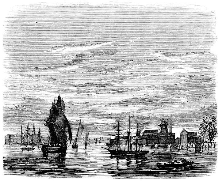
An 1859 drawing of the Thames off Millwall, including a depiction of a sail-less smock mill.
Weston’s cement works was a collection of different buildings adjoining the remains of Theobald’s Mill. In this 1870 map, the octagonal base of the former mill is clearly visible on the north side of the Windmill pub (‘PH’).

1870
According to Survey of London:
This whole jumble of structures was burnt down in January 1884, and the site was rebuilt for new occupiers, A. B. Fleming & Company Ltd, printing-ink makers and oil refiners. Flemings left after a few years, the wharf (renamed Glover’s Wharf) remaining in industrial use for a time.
In 1893 Mark Winkley, an oil wharfinger of Ferguson’s Wharf, took a 21-year lease of Weston’s and Glover’s Wharves, calling the whole site Winkley’s Wharf. Some old buildings on Weston’s Wharf were pulled down when Winkley moved in, but part of the dilapidated old cement works was still standing 20 years later.
The parts still standing must have included part of Theobald’s Mill, for Walter Besant later reported in his “The Fascination of London – The Thames” (a book published in 1903, two years after Besant’s death, and probably written during the 1890s):

Walter Besant, 1903.
At the time of Besant’s description, there was still a small section of the public right of way that was the “Mill Wall” going south from the entrance to Millwall Docks as far as the present-day Britannia Road. Just a few years later this was lost to expanding industry, and the last remains of the last mill in Millwall were removed to make room for the oil tanks of Winkley’s Wharf.
Orion Point, at the end of Claude Street, is built on the site of Theobald’s Mill. It is a standalone building, which is handy, because it’s quite easy to edit it out of a photo and replace it with a smock mill (one down, six to go) :).