
We better get this out of the way immediately; I am sure some of you may be asking yourself, “Is Cold Harbour actually a part of the Isle of Dogs?” It’s a valid question – the area has always been isolated from the rest of the Island, and it does have a different feel to it in some respects, heightened by the number of old and sometimes very large houses it contains and the distinct lack of post-war council housing. Not just a different place, but from a different time perhaps (after all, it is the oldest surviving street on the Island).
Deciding on what constitutes the boundaries of the Isle of Dogs has been keeping hundreds (well, a handful) occupied since time began (er…..since Facebook was invented). Being an avid collector of all things to do with Island history, I decided a long time ago that I needed to draw the line somewhere, if only for my own peace of mind. West, south, and east are easy – no arguing with the route of the Thames – and I also decided it should be water that defines the northern boundary; an Island has got to be surrounded by water, right? That made it easier – my Isle of Dogs is bounded in the north by the north side of the Limehouse Entrance Lock, the West India Import Dock, Blackwall Basin and the Blackwall Entrance Lock. (Don’t look for the Limehouse Entrance Lock on a map, by the way, it was filled in decades ago. Westferry Circus is now on its site.) By this definition, Cold Harbour is a part of the Isle of Dogs.

This 1890 map and other maps also support why I think the correct spelling is Cold Harbour and not Coldharbour. It was always spelled with two words on maps and in (official) documents until 1910, from which time both spellings were used although there is no evidence of any official change name. Whether it was a mistake, laziness or a conscious choice, the one-word spelling was adopted also by Poplar Borough Council in the 1930s even though the official name used by the Post Office had two words.

1940 Post Office Directory
This kind of thing still happens – recently, a street elsewhere on the Island was suddenly spelled “Saundersness Road” – clearly in error. But, with social networking and email and other electrickery, it was not too difficult to bring it to the attention of those who could correct it.
So what, actually, is a Cold Harbour (a common placename throughout the British Isles, sometimes corrupted into Coal or Cole Harbour)? Harbour has nothing to do with shipping – it means harbour in the sense of a refuge, from the Middle English herberge. Cold is from a Saxon word, cealt, which means not only cold as in temperature, but also as in bare or uninhabited. According to one definition by G. Basil Barham of the East Herts Archæological Society:
The Cold Harbours are all in the vicinity of one or other of the great Neolithic or Roman roads, and were originally the remains of partially destroyed Roman or Romano-British dwellings, or settlements [sometimes protected by earth walls, timber, or ruined stonework]. Travellers used them as being more or less secure places in which to spend a night. As the places became known, traders gathered there to distribute goods and do business, and eventually the places once more became villages, but retained the old generic name.
Cold Harbour is clearly a very old thoroughfare (or place) – older than the Mill Wall path which went down the west of the Island; older even than Dolphin Lane, (H)Arrow Lane or any of the other medieval lanes which crossed the Island marshes from Poplar in the north. That said, it is difficult to imagine Cold Harbour as being on the route to anywhere. As this 1745 map shows, Cold Harbour was a bit of a dead end – the southern end of Blackwall, a major shipbuilding area of the time.

Survey of London:
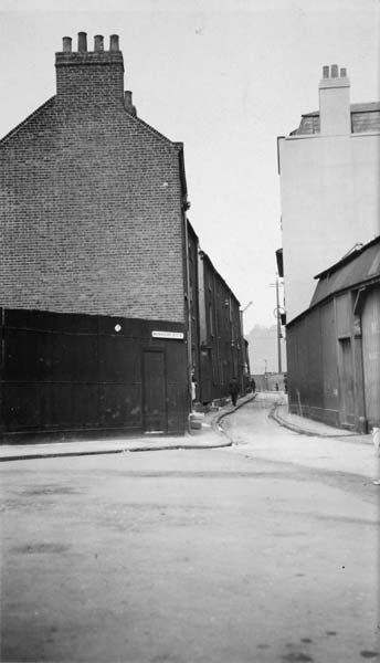
Coldharbour is virtually the sole remaining fragment of Old Blackwall. Until relatively recently it was little known and little seen, being obscured by the nondescript industrial premises on the east side of Preston’s Road. These have now been mostly cleared away, exposing what is left of Coldharbour to passers-by in the newly widened Preston’s Road.
The roadway here is the only surviving section of an old riverside road leading southwards from Blackwall Stairs before petering out somewhere near the present entrance to the South Dock of the West India Docks. This old road almost certainly originated as a pathway along the top of the medieval river embankment called the Blackwall. A deed for a house on the east side, leased in 1626, describes the house as having been built on ‘part of the wall commonly called Blackwall’, and the street as ‘the way which lieth on the same wall called Blackwall’. The name Coldharbour … formerly applied to the whole stretch of roadway, and was only restricted to the southern section after the road had been cut by the construction of the Blackwall entrance to the West India Docks.
Buildings had begun to appear in Coldharbour by the second decade of the seventeenth century, as the wave of development encouraged by the opening of the East India Company’s shipbuilding yard at Blackwall in 1614 gradually spread southwards along the riverfront, and the opening of Browne’s (later Rolt’s) shipyard in the late 1660s probably gave a further boost to the process.

Detail from the 1750 engraving ‘A View of Blackwall looking towards Greenwich’. by Boydell. Cold Harbour is in the centre of this detail.
The construction of the West India Docks disected the riverside road and isolated Cold Harbour from the rest of Blackwall.

1804
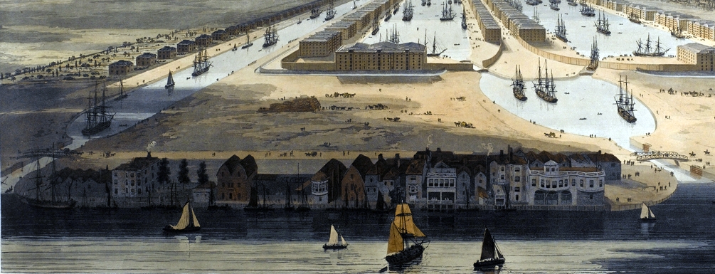
William Daniell’s 1802 painting, “An Elevated View of the New Docks & Warehouses now constructing on the Isle of Dogs near Limehouse for the reception & accommodation of Shipping in the West India Trade” provides a very detailed view of Cold Harbour at that time.
I’m jumping around a bit, now, but I find it interesting to compare this with recent aerial photos and maps.

c1950. Photo: britainfromabove.org.uk. Click for large version.

2016

c1950
Anyway, back in the 1800s, some larger houses and businesses were built along the riverfront:
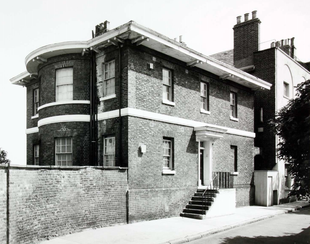
1 Cold Harbour, Isle House
Dockmaster’s residence, built for the West India Dock Company in 1825–6, to the designs of their Principal Engineer, (Sir) John Rennie.


Photo: London Metropolitan Archives (City of London)


3 Cold Harbour, Nelson House
There are stories of Lord Nelson meeting Lady Hamilton in this area – but there is no evidence to suggest a link between him and this house (first purported in 1881). The original Doric columns on either side of the front door were stolen in the 1980s – who steals Doric columns, is there a market for Doric columns? Survey of London:
In 1924–5 the house was converted into two dwellings, for occupation by PLA police families, by the introduction of a glazed screen (burnt in the fire in 1990) across the first-floor landing, and the conversion of the north-west room on the first floor to a bathroom and the south-west room on the top floor to a kitchen. In 1935 the PLA granted a 21-year lease of Nos 1 and 3 to the Bethnal Green and East London Housing Association, which divided the properties for letting to weekly tenants.


5 & 7 Cold Harbour
Survey of London:
Probably the two houses built here in 1809 by Richard Gibbs, a local shipwright, but a rebuilding in the early 1820s cannot be ruled out. The houses erected about 1809 replaced the two shown in Daniell’s view. By 1799 the northern house, whose site had been leased to Ralph Mayne in 1637, was ’empty and ruinous’, and it was pulled down before 1807, when Gibbs bought the freehold of the empty site, together with the standing house to the south.
In 1834 No. 5 was let to the West India Dock Company for an Assistant Dockmaster’s house, and No. 7 was similarly occupied from 1851. The dockmasters left when the leases expired in 1871. Between 1877 and 1890 one, or possibly both, of the properties were partly occupied as a coffee house. According to the directories, the proprietor in 1881 was William Keld, but the census shows that there were two William Kelds, one at each house. At No. 5 was a 32-year-old lighterman with a family of seven, a nurse and female servant, and at No. 7 a 55-year-old boat proprietor, presumably the former’s father.

9 Cold Harbour
Site of the Fishing Smack pub, which had been around since at least 1750. It was demolished in 1948, but a single glazed-tile column remains (see previous photo).


Site of the Fishing Smack. Photo: London Metropolitan Archives (City of London)
Recently
15 Cold Harbour
The current building was constructed in 1843–4 by Benjamin Granger Bluett, a joiner, mast- and blockmaker on the site of an older house. Survey of London:
In 1894 the Metropolitan Asylums Board (MAB), which occupied the adjoining wharf to the south as an ambulance station, bought the freehold of No. 15, and in 1895 it enclosed the former mastmaking shop, subdividing the area to make dressing-rooms, bathrooms, waiting-rooms and stores. It also built a range of waterclosets and an observation ward against the south wall of the house. Edwin T. Hall (1851–1923) designed and supervised these alterations. Ownership of No. 15 passed to the LCC in 1929, when it took over the MAB’s responsibilities. In 1969 the GLC transferred the property to the borough council.
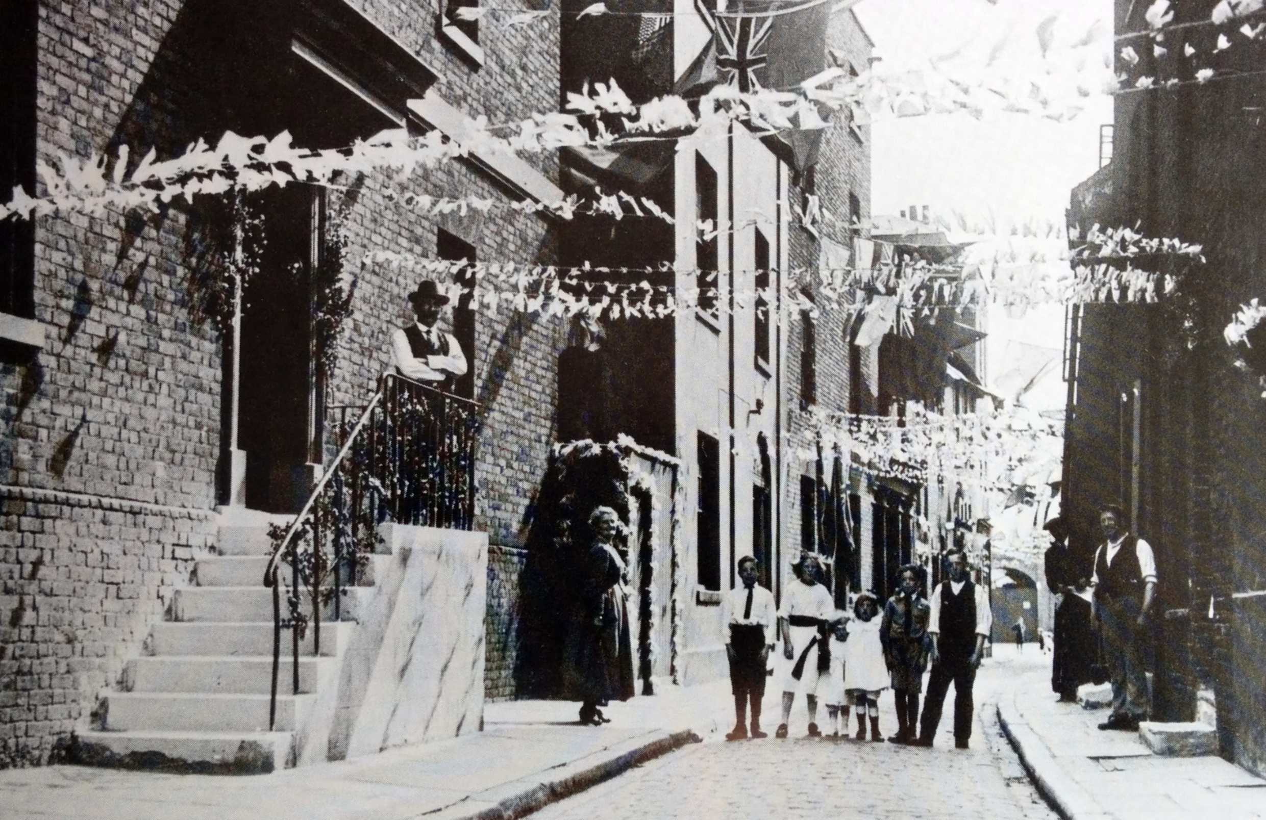
1939. 15 Cold Harbour on the right. Managers Street on the left.


North Wharf
I described the Metropolitan Asylums Board’s Ambulance Station in another article (click here).


It was around the time that the asylum board took over the wharf (in the 1880s) that Managers Street was constructed, named after the managers of the Metropolitan Asylums Board.
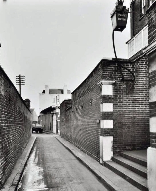
19 Cold Harbour (Blackwall River Police Station)
Opened in 1894 on the former Brown’s Wharf and closed in the 1970s. Survey of London:
The Blackwall Station, one of only two permanent river-police stations ever built on the Thames (the other was at Wapping), was designed to accommodate a division of the Thames police formerly based on board The Royalist, a hulk moored off Folly Wall. The inconvenience of this floating headquarters had long been felt, and in 1875 it was suggested that the station should be relocated on shore in the former Railway Tavern at Brunswick Wharf. This proposal was rejected, and it was not until 1889 that other land sites were seriously considered, the choice of Brown’s Wharf being approved in 1890.

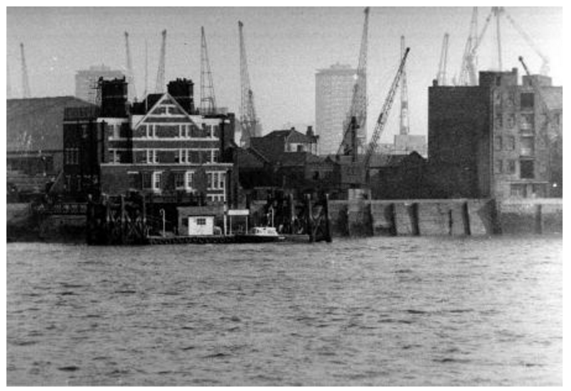
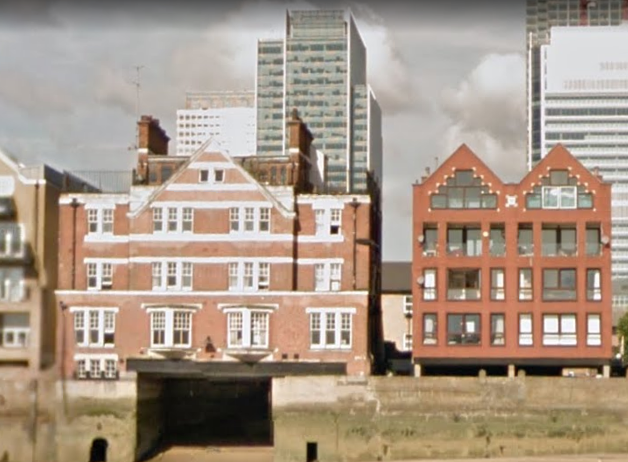
Concordia Wharf (L) and the River Police Station (R)

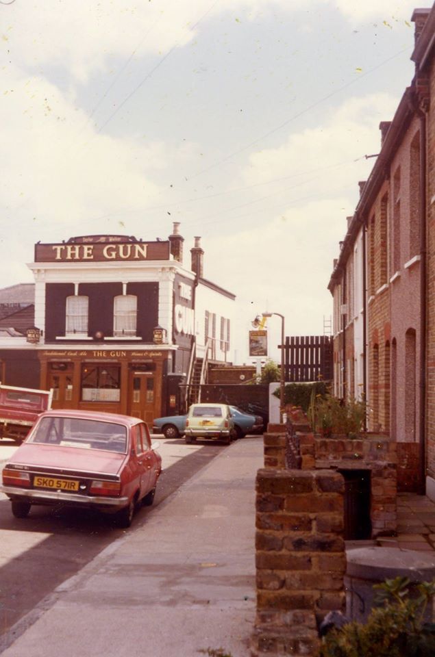
27 Cold Harbour (Gun Public House)
Doing business since the 1700s, the pub has been variously named the King and Queen (1722), Rose and Crown (1725), and Ramsgate Pink (1750). It was renamed the Gun (and sometimes referred to as the Gun Tavern) in 1771. For more photos, click here.


Nos 29–51 (odd) Cold Harbour
Built in 1890. No. 51 was demolished due to the widening and realignment of Preston’s Road.


That same widening of the road meant also the loss of Leslie’s Café 😦


West India Dock Tavern
The terraced housing in the previous section was built on the site of a grand tavern known as the West India Dock Tavern. Opened in 1830, with the owner, Samuel Lovegrove, expecting to profit from the proximity of the docks, it was not a success and remained open for not much more than a decade. For its full story, read my earlier blog article, The West India Dock Tavern.


1835 map showing “Lovegrove’s W. India Dock Tavern & Stairs”
Little is known or reported about the early history of the other side of the street. It was always predominantly industrial, but this 1870 map reveals that there was some housing in the northern section at the time. New Road was the new road between the West India Dock entrance lock and Preston(‘s) Road in the north (so-called due to it passing through the former Hall-Preston Estate):

By 1910 it was getting fuller:

Cold Harbour survived WWII remarkably unscathed, as this (sorry, poor quality) London County Council Bomb Map reveals, in spite of the V1 (flying bomb or Doodlebug) strike marked by the circle on the left. My theory is that the Luftwaffe – primarily targetting the docks – did not release their bombs until spotting the Thames, which generally saved those premises along the river in the east of the Island as the bombs passed overhead. A study of the wider LCC Bomb Damage Map for the Island does bear this out.

Uniquely, Cold Harbour retains a feel of the past, a piece of the Island (yes, it’s the Island 🙂 ) that shows its age, like these two Herberts in the Gun a couple of years ago.


Mick, I always find your articles very informative, presented and well written. Thanks.
thanks Dave
An excellent, thoroughly researched write-up. Superbly illustrated. Thank you for this labour of love.
thanks Silvia
Great effort as usual, coincidentally, no. 7 has just come on the market @ £1.7 million !!!
Who’d of thought it eh?
why am I not surprised?
Not the island it’s poplar could be called Blackwall island !
Thanks for another fascinating article. My great grandparents and my great aunt Eva Talbot lived at number 49 from around 1928 to 1974. I remember being excited seeing ships go through the swing bridge when I visited.
Pingback: An Elevated View of the New Docks & Warehouses now constructing on the Isle of Dogs near Limehouse | Isle of Dogs – Past Life, Past Lives
My great great garandparents were the William Keld’s mentioned in your article. The information is most impressive. You might like to look at our family history page on the same subject – http://www.johnh.co.uk/history/coldharbour.htm I loved the old photos in the road, we visited a few years ago and took lots of photos. Thanks Sheila Hoare
Thanks Sheila, will look at your page for sure.
I lived in Coldharbour between early winter 81 to the very beginning of 83.
So I was offered as a 17 year old apprentice bricklayer the oppertunity to live in the house in between the canterbury spa pebble dashed house and the half white stucco house. The house was empty, the central heating worked. It had been reversed so the kitchen and living area was upstairs, Vaulted pine clad ceiling with Velux windows. No fridge and oven. Had a griddle, plus the Butcher up at a parade of shops nearby took pity on me and would save me meat that had to be eaten that day, and either give it to me or sold it cheap. Lived on steak, peas and potatoes….Like a King!
The Street was something out of Eastenders. So the neighbours to my left (facing the house) were a local family, i think in the post, typical eastenders, to thier left in the cleaned up brickwork house, were a couple, the wife was a teacher/social worker, sometimes we would go swimming at the local pool, classic left wing guardian reading socialists, really thoughtful, to thier left, the white house (and new to me) two men who lived together, but old had one bed…like Morecambe and Wise…ha ha …Again nice blokes, but occasionally I would catch one of them looking a bit too long at me when I was working in the garden in the summer, (in Kevin Keegan shorts…gross). Had few Christmas drinks with them, very posh….Further down was an old boy who was in his youth a right old scaderal, he used to tell me all the stories of the docks, the pilfering, being chased by the old bill etc, but very hard times in the inter war years of the 30’s. To my right was an odd couple, a greek guy and his wife, used to have huge arguments, then all loved up….again had a few beers and wine with them. Further to the right and the owner of the land rover was a carpenter who reversed the living space and put a huge dormer in the roof (you can see it from the Bridge picture and the velux on the house i lived in).
One day I was passing and sheets of screwed up wallpaper came flying out of the house, swearing and cursing, i shouted you ok, his reply, fucking wallpaper just won’t stick to the ceiling (anaglypta notoriously hard if you don’t let it soak ) ….fuck it , fancy a pint…off to the Gun…..
I cleaned all the brickwork on the house with a wire brush and acid, racked out and re-pointed. Built a bizarre garden wall hiding the bin under the highest level of three levels, loads of mistakes, but i was 17….
Ended up working for Price demolition in between getting bits of brickwork, It wasn’t just milk that Thatcher snatched…. There wasn’t a lot of work about and with little experience I took what I could find…A few of the guys lived on the Island, always trying to get me pissed….Double port and Brandy became ( and still is) a fave,,,,for a cold…Sod lemsip…
The docks were dead, the place was quiet. The guy who bought the house for £5000 in i think 1979/80 knew that the area was going to be regenerated…clever move…I was on a pound an hour plus my apprenticeship grant of £21 pound a week i think, i maybe wrong…long time ago. But rent free…..
So pleased to find your site…Have so many fond and tough memories of that place.
Returned last year pleased to see the houses remain, shame about the gastro pub, not the Queen Vic type pub i remember… I got completely lost on the roads…
The genus loci of place has gone. Though poverty is not be glamorised, its debilitating, and for many now in Silver Town and North Woolwich it remains…
I have cleaned up those two photographs with the over red glow. Send me an e-mail and i will return.
I estimate they were taken in the summer of 82 or 83 as the scaffold was down on the house I worked and lived in, the Renault 12 of my Neighbour, plus the Land Rover of the Carpenter. I think the Lada estate belonged to the old fella….
Also the smell of the paint works opposite in the summer, the banging of the Russian Timber boats in the early hours, I would often get up and have a cuppa and watch them glide in.
Thanks again, I’m stuck in Dubai and seeing this really made my day…
Grant Beerling
hixondesign@mac.com
Brilliantly described memories, Grant. Mind if I share them in a Facebook group (‘Isle of Dogs – Then & Now’)? The more who read it, the better…..
Sure Mick, publish away!
Do you want those cleaned up photos? A big differeance…….
Please find them, and your images on my pinterest page, were you can download if you so wish….
I will read other pages of your extensive Blog…
Thanks, but don’t worry about the photos – I’m colour blind and can’t even see the difference 🙂
Where…not were…my Dyslexia….
Fascinating and interesting article. I moved to Coldharbour in 1984 with my parents and left in ‘87, although they were there a few more years. We lived in Flat 5 of the old Police Station after it had been converted. We had always thought the derelict area either side of Managers Street were bomb sites, but apparently not!
Thank you so much for this information! I was piecing together some family history and your article helped flesh out some details. I believe my Great Grandmother was born at 3 Cold Harbour around 1876 (I understand she shaved some years off her age – now and then- who knows what she told the 1940 census). I came across a snippet about her father’s company, WC Reeder & Co. doing work in 1899 at Blackwall in Cold Harbour. Nana always said she was born on the Isle of Dogs at Nelson House. When I looked up the official Nelson House, it didn’t fit. We have a few tall tales in the family so we moved on with a shrug of the shoulders. Now the information fits. Now I just have to place the family there in 1873-76! I loved your article and will read some more of your work.Thank you thank you!
Thanks so much for this fascinating history. We were in Coldharbour on Wednesday seeking links with the history of my wife’s forebears, the Jacksons, who took over the mast and block business at number 15. Had to have a pint in The Gun, hoping it would have been Joseph Jackson’s “local”, though perhaps he preferred The Fishing Smack.
Thanks for your comments, Hugh.
A painting we found recently which clearly shows Caro’s ancestors’ shipwrights business on the left, with a mast under repair protruding from their workshop at 15 Coldharbour, and part of the name “Jackson” and trade “Shipsmith” visible in the top left-hand corner (hope it opens on your page – not sure how to post photos there):