The London and Blackwall Railway (originally named the Commercial Railway) opened in 1840, and ran from East Smithfield to Poplar, more or less in parallel with – and south of – Commercial Road and East India Dock Road. This route passed close to all the major docks on the north side of the river, from St. Katharine to the East India Docks.
In 1863, the London and Blackwall Railway Company proposed to create a branch line from Limehouse down the west side of the Island as far as the ferry to Greenwich in Ferry Street (then named Wharf Road). The East and West India Dock company successfully opposed the plan, concerned as they were that it would take business from them.
But, when the Millwall Docks were constructed, the dock company was forced to overcome its reluctance and allow a branch line; not down the west of the Island, but east of the new Millwall Inner Dock and terminating at the North Greenwich Railway Station (which evidentally was a finer sounding name to the owners, despite its geographical inaccuracy).
This branch line was known as the Millwall Extension Railway. It was never very popular, and only saw significant passenger numbers when Millwall were playing at home, a situation which changed when the team moved south of the river in 1910. Around this time, too, motor buses were becoming more prevalent and popular.
By the 1920s, the line between Millwall Dock and North Greenwich Station was no longer used, and the remaining section for freight only. In 1929 the Millwall Extension Railway closed completely, and a few years later the bridges over Glengall Road, East Ferry Road and Manchester Road were demolished.
In the early 1980s, however, much of the still-existing infrastructure was used as a basis for the Docklands Light Railway: Crossharbour DLR Station was built on the site of Millwall Dock Station, Island Gardens DLR Station was built on the site of North Greenwich Station; and new bridges were built over Glengall Road, East Ferry Road and Manchester Road.
Meanwhile, back in Victorian times, the new branch line started at a new junction station, Millwall Junction, which opened in 1871 just south of Poplar High Street near Harrow Lane.

Millwall Junction in the late 1970s (estimated). The old ‘Canada’ blocks of flats on Preston’s Road are visible in the background.
Further south, the railway passed over two iron swing bridges which spanned the cuttings between Blackwall Basin and the West India Import and Export Docks.
A little further south was the South Dock station. This was completely surrounded by docks (thus not accessible from a public right of way) and was staffed by dock company employees.
Millwall Dock Station
After crossing another swing bridge, the railway line reached Millwall Dock Station on the corner of East Ferry Road and Glengall Road, diagonally opposite the George.

Millwall Dock Station looking north on East Ferry Road, which veers to the right just beyind the cyclist on the right. The light building is on the north west corner of Glengall Road and East Ferry Road.
Looking in the opposite direction:

Dockers passing under the Glengall Road railway bridge, heading for the area outside the George, which was a gathering place for the call-up. Year of photo: 1940.
The line ran further south on an embankment parallel with East Ferry Road, crossing the road close to Hawkins & Tipson’s Globe Rope Works.
The railway viaduct actually separated its East Ferry Road frontage from the rest of the works, but when the Millwall Extenstion Railway closed in 1926, the rope firm acquired and demolished the short, intruding section of viaduct.

1949 aerial photo showing original path of railway line through Hawkins & Tipson. It also shows the bomb damage to the arches.
Traces of the old bridge supports were still visible as late as the 1980s.
And in the 1980s, Mudchute DLR Station and a new bridge were constructed at the spot.

East Ferry Road looking north, remains of Hawkins & Tipson on the right. Photo copyright (c) Mike Seaborne.
Later, the DLR line would go underground just before this point, emerging in Greenwich, but at the time of its opening, it followed the old Millwall Extension Railway arches.

Steam train on arches through Millwall Park (before there was a park). East Ferry Road is in the background.
The railway crossed Manchester Road near Johnson Street (now part of Ferry Street)
After the closure of the Millwall Extension line, the bridge was demolished…..

1936. Photo: London Metropolitan Archives (City of London)
On the construction of the DLR, a new bridge was built to the Island Gardens DLR Station which was just across the road, on the site of the old North Greenwich Station…..
Only to be removed again when the DLR was directed underground and Island Gardens DLR moved across the road (left in this photo)….
North Greenwich Station
North Greenwich Station opened in 1872 on land acquired from Island Gardens (which extended all the way to Johnson’s Draw Dock at the time; later more park was lost to the foot tunnel).
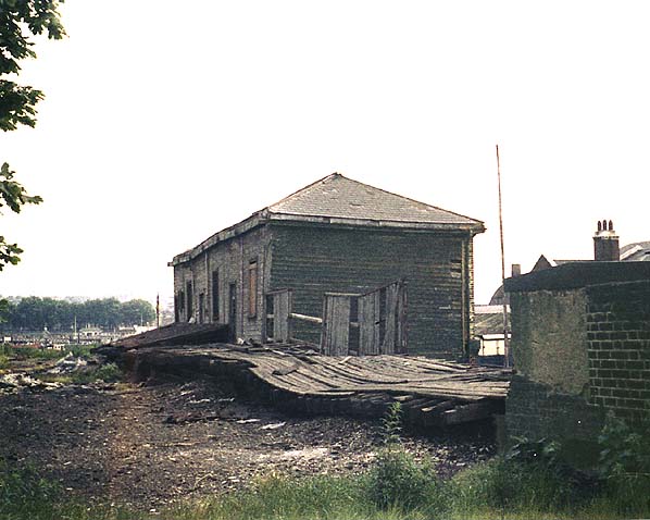
After the line closure, the station was used by wharfingers, who stored (sometimes dangerous) barrelled substances in the open air. In 1955 a serious fire broke out to the right of this photo, threatening houses which backed onto the yard.
The following photo shows the station building from the other side, from Saunders Ness Road. Just visible on the right is the entrance to the pedestrian subway that went from Saunders Ness Road to the station:
The Thames Tunnel (Greenwich to Millwall) Act of 1897 had authorized the LCC and the Great Eastern Railway Company (GER) to build a ‘subway or other means of communication’ connecting the Poplar entrance shaft with the GER’s North Greenwich Station. Following negotiations between the LCC, GER and the Millwall Dock Company, in 1903 a subway was constructed between the tunnel and the station.
– Survey of London (Athlone Press)
Very shortly after the previous photo was taken, the station was demolished, making room for a new clubhouse for the Poplar, Blackwall & District Rowing Cub (which had been storing its boats in a wooden shed nearby, and using the Princess of Wales – ‘Macs’ – as a clubroom).
As mentioned above, the Millwall Extension Railway was not a commercial success. It is ironic (and very unusual by Island standards) that its unused and sometimes derelict infrastructure has been preserved and even revived in many places, close to a century after the extension stopped operating in the 1920s.
For more information (and source of some images in this article), I recommend the excellent http://www.disused-stations.org.uk/sites.shtml.


Pingback: The History of Saunders Ness Road | Isle of Dogs – Past Life, Past Lives
Pingback: Statues: Woman and Fish. - London Tangents
Pingback: Ferry Street, Isle of Dogs – A History | Isle of Dogs – Past Life, Past Lives
Pingback: The Ferry That Never Was (a Close Shave) | Isle of Dogs – Past Life, Past Lives
Modelling the railway station at North Greenwich Station I am still looking for details of the loco shed. Any photographs of the shed would be most helpful.