
There are occasionally discussions in various Facebook groups – well, the ones that I’m a member of – about the geographical extent of the Island. The river’s an obvious boundary, but what about the northern boundary? Where does the Island end (or start)?
Isle of Dogs was first used as an official place name only as late as the end of the 20th century, when the London Borough of Tower Hamlets introduced various administrative “Neighbourhoods” throughout East London. You will not find a map before then with an official boundary.
Although the name existed for centuries before the arrival of the docks, I tend to use the docks for my own definition of the extent of the Island, with the northern boundary marked by the Limehouse Entrance Lock in the west, West India Docks, and the Blackwall Entrance Lock in the east. (Don’t bother looking for Limehouse Entrance on a map, the lock and basin were filled in almost a century ago, Westferry Circus is more or less on the site today.)

c1830
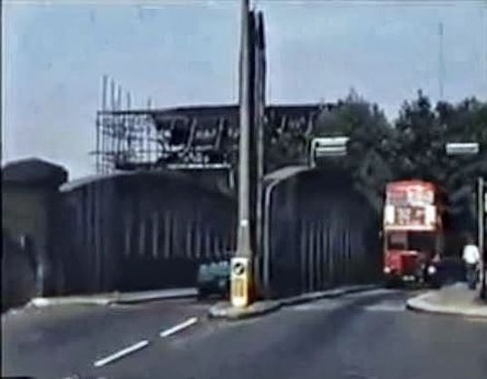
Many Islanders will remember the swing bridge that spanned Blackwall Entrance Lock, with its tight northern approach bend which caused buses and lorries to swing out on the other side of the road in order to get onto the bridge without mounting the pavement – or not, as in this case:

Blackwall Entrance Lock was the entrance to Blackwall Basin, where ships could turn and enter or exit the West India Import or Export Docks. Its construction lopped off the southern end of Blackwall – a 400 year old centre of shipbuilding and repairing – dramatically shortening Cold Harbour, the main road along the river at the time.

Blackwall from the Thames. Francis Holman, 1784 (National Maritime History Museum)
Survey of London:
The entrance to the West India Docks from the river at Blackwall was the most critical point of the original dock system. The fortunes of the dock proprietors turned on its suitability for shipping. The original intention was to provide a gated entrance, but in late 1799 it was decided that a lock should be constructed, to provide greater control over water levels and to reduce silting. Excavation of the lock pit began in 1800, before Jessop and Walker had settled the dimensions of what was to be the largest lock in England, at 45ft wide, 191ft 6in. long and 23ft 3in. deep at high water.
Six workers were killed during the construction of the lock due to a breach of the coffer dam which was meant to keep the Thames out, but this did not prevent the opening of the lock less than a month later, on 27th August 1802. The locks and lock gates were plagued with problems and needed to be frequently repaired in the following century. And, as with other entrance locks on the Island, the increasing size of ships meant it had to be rebuilt.

1894 reconstruction

1894 reconstruction

Official re-opening
Before the rebuild, the road south of the lock was known as New Road, and the road heading north to Poplar was known as Preston New Road (or Preston’s Road on other maps of the time).

c1870
Due to the increased distance between the lock gates, the road was rerouted a few yards to the east.

c1895
The ‘Engine House’ marked on the map was an impounding station, similar to the one in the west of the Island, which is still functioning and doing its job of maintaining the water level in the docks. Survey of London:
The Blackwall Entrance impounding station was made redundant in 1930 by the introduction of impounding machinery at the South Dock. In 1936 the building was leased to become part of Edwin Cooper & Company’s Northumberland Wharf oil and grease factory. From 1952 it was Raleana Works, the premises of the Thames Welding Company, a subsidiary of the London Graving Dock Company. The building was demolished in 1986.

1894
This 1950 aerial photo shows the building in 1950, along with a few other features – many long gone, but the area still has a few of its original buildings.

1950
Some of my favourite photos of the Island show men heading to or from work near the bridge.

Looking north. Photo: London Metropolitan Archives (City of London)

Looking south. I admit by my own definition this is not actually the Island, being a few yards north of the bridge. Photo: London Metropolitan Archives (City of London)

Ah, not only men, spotted a woman in this photo. She looks quite posh for the Island. Photo: London Metropolitan Archives (City of London)
And any photo of a bridger is always impressive, espcially when a large sailing ship is passing through the lock:

In 1929, a new, larger West India South Dock entrance was opened three hundred yards to the south (site of present day Blue Bridge). Around the same time passages were created to link the Import, Export and South Docks.

1936
This made the Blackwall Entrance Lock more or less redundant. It was closed completely in 1940 as it needed repairs but the war prevented these from taking place, and it reopened only for barge traffic from 1950.

This fabulous little film shows extracts from a 1960 documentary about Queenie Watts, who was from the Island. It starts with scenes of the entrance lock in use.
The bridge was always a popular place to take photos or make films of buses for some reason. Then again, I suppose it was an impressive sight, a large vehicle squeezing itself through a small space, sometimes at alarming speeds. I took it all for granted back then.


Photos of other types of vehicle, and even non-vehicle views, are also available:


The lock was last used in 1968, at a time when the West India Docks were almost wound down (work kept going at Millwall Docks, but only for another decade or so). In 1970, the lock was used as the backdrop for some scenes from the very awful film ‘The Walking Stick’, starring David Hemmings (I know it’s awful because I’ve seen it – I even paid for the DVD – but it was worth it to get some more images of the Island).


The entrance lock was already looking a bit forelorn in 1970. Photos taken in the 1980s show the decline.


The previous photo shows that something was afoot at the end of the 1980s; new houses and other buildings were being constructed on the former docks and industrial land, as can be seen in the following photos.


 In 1987 the middle lock gates were removed and the entrance lock permanently dammed. Not long afterwards the bridge was removed and Preston’s Road was broadened and straightened.


The Island has changed hugely in recent years, but this is one of two areas where I have found it particularly disconcerting. All that stuff in and around the docks – it’s just new – and I can’t compare it with the past because I never went in the docks anyway (well… maybe, but I never nicked anything).
And outside of the docks, many original roads are largely still recognizable: Manchester Rd, Westferry Rd, Stebondale Street, Tiller Road, Glengall Road, Cahir Street, and so on – there’s plenty enough still there for me to know where I am. But, the first time I drove from East India Dock Road onto the Island after not visiting for a few years, I had no idea where I was, I literally stopped the car and reversed up the street when I realised that I’d just driven over what was once the Blackwall Entrance Lock. Where was the bridge, why was the road so wide and straight, where are all the old buildings? Where was I? It was only when I saw the Blue Bridge in the distance that I could calm down a bit. 🙂
I mentioned two areas where I have found the change particulary disconcerting; the other area is where The Walls were. Is it a coincidence that this is the western end of my self-defined, Island boundary? Both were areas where I would feel like I’d arrived home when heading south from Limehouse or Poplar, and now I don’t recognize them. Maybe I ought redefine my Island boundaries.


So interesting Mick some parts of the Island are completely unrecognisable but it is good to know that still a little bit of the old Island left.
Another fascinating piece, Mick, with splendid photos. Love the tall masts of a sailing ship holding up traffic on a ‘bridger’, and RT buses squeezing through.
thanks again, Nicholas
This brought back many memories. I lived on the Island from 1953 until I got married in 1977. My mother’s side of the family had lived there for many many years before. In my early childhood we lived in the prefabs in Strattondale Street which was just off Manchester Road near the ‘Big Bridge. My grandad worked in the Graving Dock which was near the swing bridge. I haven’t been to the Island for years and I, like yourself, would not recognise anything until I reached the ‘Blue Bridge’ which I remember being constructed. That was a pain….had to bus it up the dock, get off the bus and walk across the lock, then catch another bus to continue the journey up to Poplar. I do remember the swing bridge holding up that part of the journey if it had swung round to let the barges through…not as often as the big bridge though…..that made me late for school, or even work later on in my life, many a time! Anyway, was great looking at those photos. Thanks for the memories….very enjoyable.
thanks for the comments Gillian, and glad you liked it
As a bus driver in the 1960s, I remember the bridge quite well. Approaching from the north the nearside kerb on entering the bridge was reinforced with steel. On a good day we could usually enter the bridge “without splashing the sides, on a bad day we would slide the rear wheels round the steel kerb. This was not a problem as our buses were equiped with the special “Tunnel Tyres” as the buses also worked the 108s through Blackwall Tunnel and the 82s through Rotherhithe Tunnel.
Pingback: An Elevated View of the New Docks & Warehouses now constructing on the Isle of Dogs near Limehouse | Isle of Dogs – Past Life, Past Lives
Hi Mick, thanks for a really interesting article. I am a writer and editor writing a novel for kids, set in the late 1850s, and am trying to work out how easy it would have been to get, firstly, from a rowing boat up on to the quay next to the Blackwall Entrance lock, and then, secondly, on foot from there in to the West India Dock and its warehouses. I understand that there were tall brick walls (and moats?) around some of the area, but can’t work out where these would have been. The photos in your article make the lock entrance look quite accessible on foot. Any light you can shed or directions you can point me in would be very gratefully received – thank you. Iona
Hello Iona. You could indeed get up to a quay next to the entrance (but not without wharf workers wondering what you’re up to – the wharves were private land). But I doubt very much if you’d get any further – for example into the docks. There were walls, very high ones in most places, and any entrances would have had PLA police guarding them. The whole point of the enclosed docks was to keep people out. Best bet would have been to stow aboard a ship or vehicle entering the docks (not an easy thing to do, and it doesn’t solve how you’d get out again). Interesting 🙂
Thanks Mick – that’s very helpful. Yes, stowing away sounds like the answer and I think I’ve figured out what they do it on. Thanks again