
The junction formed by Westferry Road, East Ferry Road, Manchester Road and Ferry Street has appeared in many photographs over the years. In great part this is because two of the Island’s best-known original buildings – the Lord Nelson public house and the fire station – stand here.
Originally, many centuries ago, this was not a junction. The road from Poplar to the Greenwich Ferry (the present-day East Ferry Road) was one of just a couple of roads on the Island, although they were not much more than dirt paths. (The history of East Ferry Road is described here, by the way).
This 1741 map shows two lanes, Angel Lane, which was more usually called Dolphin Lane, and Arrow Lane, which was more usually spelled Harrow Lane (I like the way the aitch has been dropped, a cockney cartographer!). Both Dolphin Lane and Harrow Lane still exist, in much shorter forms, as side roads of Poplar High Street.

1741
The opening of the West India Docks in 1802 led to the creation of a (toll) road from Limehouse to the Greenwich Ferry, in order to facilitate the transport of goods and workers. The road was originally known as the Deptford & Greenwich Road. And, not shown on this map, the newly-widened and paved East Ferry Road was known as the Blackwall Road. It would be circa 1860 before the roads received the names we now know.

1820
A couple of decades after this map was created, Cubitt started to build his houses in the east, which led to the need for a main road around that part of the Island. Why he named it Manchester Road, I don’t know, but would like to find out. This 1850 map shows Manchester Road, but actually most of it wasn’t yet built at that time; it was 1854 before it was completed.

1850
One of the first parts of Manchester Road to be built upon was close to the corner with East Ferry Road, where wine merchant Henry Johnson built the Lord Nelson. Johnson’s brother Augustus ran an ironworks in Ferry Street, after which Johnson’s Draw Dock was named – the section of Ferry Street between the draw dock and Manchester Road was originally named Johnson Street.

1861

c1900. The Lord Nelson had more ornamentation when it was first built. Photo: London Metropolitan Archives (City of London)

c1900. East Ferry Road, shed and stables at the rear of the Lord Nelson. Photo: London Metropolitan Archives (City of London)

c1900. East Ferry Road, shed at the rear of the Lord Nelson. Photo: London Metropolitan Archives (City of London)
Originally, William Cubitt offered to build a fire station on the Island in the 1850s, but it was not until 1872 that action was undertaken, significantly influenced by local concerns that – if a bridge was up – there was no way that an engine from the fire station at West India Dock Road would be able to attend to an Island fire on time.
The Isle of Dogs Fire Engine Station, was opened in 1877 on undeveloped land owned by Lady Margaret Charteris, a major Island landowner and wife of Lord Strafford. It housed six firemen, a coachman, three horses, a steam fire-engine, a manual engine, a curricle and a fire-escape. (See here for more information about the fire station).

1890

c1900. Photo: London Metropolitan Archives (City of London)
Survey of London:
In the mid-1890s it was realized that the building was too small. Because of an increase in the number of staff, some of the men had to be lodged in houses in the neighbourhood, and a pair of horses was kept in rented stables. Additional ground to the rear of the station was acquired, together with the freehold of the original premises, and plans were prepared for the alteration and enlargement of the building. These plans were not executed and revised ones were produced in 1903, but the estimated cost of carrying them out was such that it was decided that it was preferable to erect a new building.

c1904. The new Isle of Dogs Fire Station (only later would it be named Millwall Fire Station)

Fire station not long after opening. Photo: London Metropolitan Archives (City of London)
This photo, taken shortly after 1918, shows the view from Ferry Street towards Westferry Road, Manchester Road and East Ferry Road. It is one of the very few photos which show the houses on both sides of the street.

Post-WW1 street party. Looking from Ferry Street.
Virtually all houses on the south side of the street (left) were damaged beyond repair in WWII. Those on the north side fared better, but the whole row was also demolished later. This 1950 aerial photo was taken in the same direction as the previous photo – damage to the houses on the left is more obvious.

c1950
This c1950 map describes the houses as ‘ruins’.
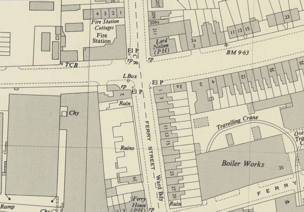
c1950
The larger building on the corner of Ferry Street and Manchester Road, visible in the post-WW1 photo and c1950 map (No. 1 Ferry Street) – housed a greengrocer’s in the 1950s. There is a just a hint of it in this photo, the view looking up Ferry Street.

Summer 1952. Outside “Boston” Skeels’ greengrocer’s shop. Harry Smith at the back, L to R at the front: Mr. Long, Bill Smith and Mr. Sparks. Photo: Island History Trust.
The rear of the shop can be seen in this 1960s photo taken from an upstairs room in the garage opposite the Lord Nelson.

1960s. Photo: Island History Trust / Mr Hart
Ten years’ later and the shop was gone. The street sign – possibly the only one which named Millwall – is the wrong way round in this photo. Some oik or other has decided to turn it 180 degrees.

c1970
In this photo of the fire station, the street sign is the right way round. Also visible is the newsagent’s and tobacconist’s on the corner of Westferry Road and Ferry Street.


Fag break at Associated Lead. Lil Devonshire, Ivy Hawkins, Daisy Warren, Jean Haxell and Dolly Winch enjoying a break outside the entrance to Associated Lead in Ferry Street. Photo: George Warren, looks like it was taken in the 1960’s

1974
The junction was also in the background of a scene from the Prospects TV series. (I think, by this time, the corner shop had become a suntan salon or similar).


1980s

Snack van on the corner of Ferry Street and Westferry Road, where the newsagent’s used to be.

Snack van on the corner of Ferry Street and Westferry Road, where the newsagent’s used to be.
As with many scenes of the Island, the horizon began to get crowded in the 1990s.
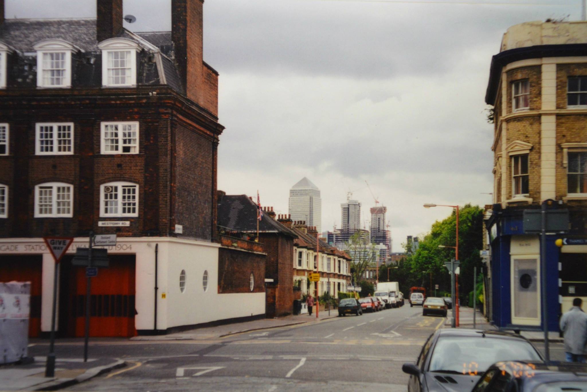
Photo: Peter Wright
The roads have got a lot busier too, which doesn’t always turn out well.

In 2008 the former Millwall Fire Station was converted into apartment blocks named for Violet Pengelly and Joan Bartlett, members of the London Auxiliary Fire Service killed during bombing of their depot at Cubitt Town School in Saunders Ness Rd during World War II, along with more than 20 colleagues. I’ve written about this incident in my book, The Isle of Dogs During World War II, and it features in Bill Regan’s Wartime Diaries.
As for the main building, the ground floor was converted into a restaurant– The Old Millwall Fire Station Restaurant.
How’s the junction looking these days? Not too bad, actually.


Hi Mick
I don’t know why William Cubitt named Manchester Road on the Ise of Dogs
But I was reading that he was heavily involved in canal construction.
There is a ship canal in Manchester and I wonder if there is any connection ?
Cheers
Rich
He was involved in the construction of Ellesmere Port, on the Manchester Ship Canal, but I’ve not been able to find out other Manchester links.
“One of the first parts of Manchester Road to be built upon was the north side, at the corner with East Ferry Road,”
Should that say south side?
You’re right – the cottages across the road to the Nelson were there before the pub. Thanks.
Thanks for another interesting piece, Mick, beautifully illustrated. There is a 1984 photograph of the Lord Nelson shot from Cyclo Motors’ yard obliquely across the street in a handsome new book by photographer Mike Seaborne: ‘The Isle of Dogs Before the Big Money’, published by Hoxton Mini Press with an essay by Ken Worpole.
Thanks Nicholas, I know Mike Seaborne’s photos, and the one you refer to.
Really enjoying this site and your diaries from the 1970s.
Any idea where this might be? It was taken in the early 1980s not too far from the foot tunnel so maybe Westferry Road? https://pbs.twimg.com/media/DwVSfqpXcAAxPGW.jpg
Thanks Martyn. I don’t think the photo was taken on the Island. I don’t recognize it, and there was never a street with an even house number as high as 476. Curious, will look into it some more – must have been a long street/road.
As you emerged from the foot tunnel in Island Gardens, there used to be a kiosk directly on the left, hard by the boundary wall. Could this be it?
Thanks Mick. I’ve looked back at the photos from that day and that was the only one of derelict buildings – all the others were at the other end of the tunnel. It seems to have been autumn 1985.
You were right, of course. In fact I took a picture of Metropolitan Wharf from across the river in Rotherhithe. https://pbs.twimg.com/media/DwbDYDbX0AE2kTD
And the London Gazette entry for one D G Hall (bottom left on the page) refers to 476Rotherhithe Street, so that was probably it. https://pbs.twimg.com/media/DwbDYDaX4AAg7ci
Fixed links, I hope!
nice photo!