[Excuse me for drifting slightly off the Island for a moment, but I do think it is a place and subject which would be of interest to most Islanders.]
If you stand at Johnson’s Draw Dock next to the Rowing Club and look across the river, you will be greeted with this well-known and splendid view:
Dominating the view is the Cutty Sark, As I’ve mentioned a countless times in other blog articles, undoubtedly boring everyone stupid, I walked through the foot tunnel to school in Blackheath for 7 years, thus passing the famous tea clipper twice a day during this period.
I never really thought about how long the Cutty Sark had been there; it could have been forever as far as my young mind was concerned. It’s only recently that I learned she was moored there in a purpose-built dry dock ‘only’ 61 years ago, in December 1954.

The Cutty Sark being moved into the flooded dry dock. In order to ensure that she floated high in the water (the dock was not so deep), anything that could be removed was first removed from the ship.
Learning this made me curious about what was on the site before the Cutty Sark. What did Islanders see when they looked across the river before 1954? What did they see when they walked out of the tunnel building over the water?
A 1947 map shows it was quite built-up at one time, with a small amount of open space directly to the east.
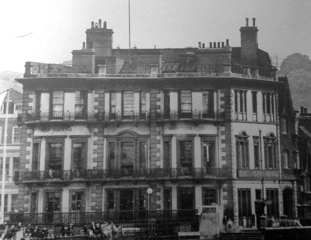
That open space did not exist before the war. There used to be a very grand pub here; the Ship Tavern. Unfortunately, the pub went the way of many pubs between 1939 and 1945; it was destroyed by bombing. This post-war aerial photo shows a little of the pub’s rear still standing, and also demonstrates how much bomb damage there was in this small area.

1947
This pre-war photo shows the Ship Tavern in better days.
Other photos show the pub’s surroundings. I particularly like this one; it shows the pub’s entrance which faced the tunnel entrance building (just out of view to the left). This is what Islanders would first see when they emerged from the tunnel. The Island itself can just be glimpsed in the background beyond the river stairs.
This are even older photos of the pub entrance and the stairs (known as the Garden Stairs), taken before the tunnel was built and opened in 1902. The buildings on the left would be demolished to make room for the tunnel entrance building.

This 1893 map shows the pre-tunnel area.
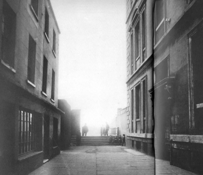
The narrow Brewhouse Lane appears in the following photo. The Ship Tavern is far right, the Thames and the Island can be seen in the background on the left, and the small dock in the lower left was known as Billingsgate Dock.
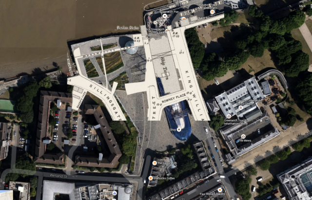
Superimposing the 1893 map on a satellite photo.
I am aware that I’ve not only drifted off the Island, I’ve also drifted back to a time when there was not even a tunnel. It’s a fascinating area, worthy of more investigation, and very well documented by Greenwich (amateur) historians. Definitely worth having a Google if you’re interested.


Great bit of research, Mick! On the subject of when the Cutty Sark was opened, I see it was in June 1957. I remember that my brother went to Greenwich to see the opening and, when he came home, told us that the dignitary introducing the ceremony, had called it the “Sutty Cark”. We didn’t believe him til we watched the news that evening!! It did see a very strange name at the time!!
It is a lovely area and the history is fascinating. I must admit I found the tunnel a bit scary!
Thanks Diane. The tunnel never bothered me, but the other end looked a bit scary all those years ago.
When I was 10/11 my mother moved back to the Island,but because of my 11 plus I continued school in Greenwich. I used to come out of the subway and through an arch, as the row of houses came right upto the pier. As my school was nearby we were brought upto see the Cutty Sark towed up. This was all about 1954. Barry Mahar
Interesting and I learnt something today. Always thought the dock pre existed and was not built soley for the Cutty Sark. The Greenwich site you mention is also interesting having looked for something a while ago. The power station is worth a google as I wondered why it was one of thevery few remaining on the Thames in London. The first succesful trans Atlantic submarine cable was manufatured at Enderbys Wharf in Greenwich. Hopefully this will post as it’s my third attempt.
Hi George, your first posts got through too, but until I approve comments they don’t appear, and I was asleep at the time 🙂
Thats fair. I might appear an insomniac but often I’m on different time zones.
Hi Mick yes I remember this happening (was just coming up to 17 at the time!!) and then some years later they put Sir Francis Chichester’s boat on the other side of the tunnel entrance!i
I used to go through the tunnel very often as a kid and later when I worked in Greenwich every day. I have to say I did find the tunnel a bit scary but only late at night!
Interesting article and fascinating photos; thanks, Mick. There is a little book about the former industrial area immediately to the west of the tunnel entrance: ‘Victorian Wood Wharf and Greenwich Riverside 1820-2010’, by Ronald Richards and Derek Bayliss. Available from the Greenwich Visitor Centre, £5.
Thanks Nicholas.
Excellent post!!
The dignitary concerned was The Queen according to my mum who watched it on the ‘telly’.
My Gt.Gt.Grandfather’s coal business was in the previous photo in Brewhouse Lane, showing one of his colliers docked up outside. The Huntley’s have been in Greenwich since the 17th Cent.
My ancestors lived on Brewhouse Lane in the 1790s. Couldn’t get much closer to river than that!
Thank you